An Atlas of Radical Cartography pairs artists, architects, designers, and collectives with writers to explore the map's role as political agent. These 10 mapping projects and critical essays take on social and political issues from globalization to garbage.
The publication, a boxed set including a book of essays and 10 fold-out maps, will be published in September 2007 by the Journal of Aesthetics and Protest Press, Los Angeles.... This is an independent publication, produced and created by artists. We see this as a collective effort, and so we ask for your help in covering the printing costs. All profits will go to compensating the writers, mapmakers, editors, and designers. Donations of $35 or more receive a complimentary copy of An Atlas!
Lize Mogel & Lex Bhagat (Editors)
Map: AnArchitektur, "Geography of a Border"
Essay: Sebastian Cobarrubias & Maribel Casas-Cortes, "Drawing Escape Tunnels Through Borders: Cartographic Research Experiments by European Social Movements"
The drama of these [mass border crossings and detention-center riots] belies the increasing complexity of the border regime developing in the European Union. This regime is more than policed national borders - it includes the development of pan-European border policies through agencies such as FRONTEX, international organizations such as the IOM (International Organization on Migration), as well as myriad of prisons and holding centers for migrants strewn throughout the EU and beyond. The mix of the explosiveness of the issues and the increasing complexity and mobility of the border regime has led to many collectives/artists/activists to dig into these questions.
The border is beginning to multiply and fractalize both within and outside the razor wire fences in Eastern Poland or Ceuta. This challenges our ideas of the border as the geographical edge of a country/nation (where the color changes on the school map.) The logic of the border goes beyond physical check-points to permeate labor, institutional, family and other relationships. The population is stratified according to "internal borders" that create divisions between EU citizens and extra-communitarians. This separation is marked by an inherent racism used to justify the aggressive border regime. Among the initiatives that question this proliferation of the border, many activist efforts have used cartography as a tool in order to reorient themselves through the dizzying institutional maze of the EU border regime. In the next pages, we will explore cartographic interventions as activist experiments that are part of the burgeoning activity on border mappings in the EU.
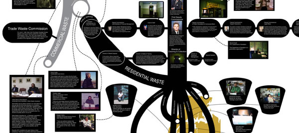
Map: Center for Urban Pedagogy, "New York City Garbage Machine"
Essay: Heather Rogers, "The Power of Garbage "
"Where you gonna go? Who you gonna get? No one's gonna service you!" yelled a Barretti Carting Corporation representative into the phone before slamming the receiver down. This was customer service in New York City under the notorious Mafia-led garbage cartel. Clients who didn't like their rates or wanted to switch haulers had a lot of trouble on their hands. Fussy patrons might suffer verbal abuse, or they might get a visit from their garbage collector, which wasn't always a pleasant experience. "Hey, why send a poodle when you can send a pit bull?" a Barretti enforcer explained.
Since the mid-1950s, when local officials handed over commercial waste collection to private haulers, New York City's garbage industry had been dominated by a Mafia-led cartel. (The city government's Department of Sanitation has continued to collect residential garbage). Under this regime, most shops, restaurants, offices and large apartment buildings suffered the fate that Barretti's customers were subjected to. The Mob was in charge of garbage and, it seemed, no one could stop them. Some of the Big Apple's trash carting businesses were more directly Mafia-connected, like Barretti, but many were not; yet if they wanted to run their collection trucks down New York City streets, they had to join the cartel. The payoff for being a member was guaranteed customers and a healthy income--in other words protection against the market forces that might drive prices down and companies out of business. Estimates put the amount that the cartel overcharged its customers in the hundreds of millions of dollars each year.
All this ended rather abruptly in the mid-1990s when the Mafia's New York City garbage monopoly was destroyed. The confluence of forces behind the cartel's demise included a police crackdown on Mob activity and, perhaps more significantly, a major restructuring in the garbage industry. No longer was refuse treatment simply a service municipalities conducted themselves or contracted out to quaint mom-and-pop hauling companies. Multinational trash corporations, started in the 1970s and 1980s by a handful of innovative refuse firms, were seizing control of the garbage trade.
Two early players in the corporatization of garbage were Waste Management, Inc. (WMI) and Browning-Ferris Industries (BFI). These conglomerates spearheaded the consolidation of the industry, buying out smaller firms in towns across the Sunbelt, then spreading north and into international markets. In building their empires, WMI and BFI brought the dark and fetid world of rejectamenta into the realm of billion-dollar revenues and the New York Stock Exchange, and in the process radically remade garbage handling. Among the most significant changes the rubbish conglomerates wrought were the domination of the waste market by a few large firms, the reinvigoration of the sanitary landfill, and the exporting of garbage. All of these changes happened in rapid succession in New York City during the 1990s as the Mafia was driven out of the garbage trade.
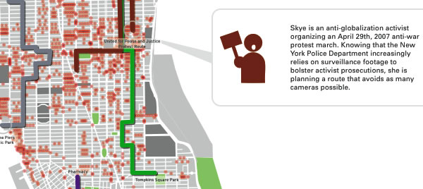
Map: Institute for Applied Autonomy & Steve Rowell, "I-See Map"
Essay: Institute for Applied Autonomy, "Tactical Cartographies"
In taking up the term "tactical" in an arts context, we link cartography with "tactical media," an approach to art production that privileges critical social engagement. Since the early 90's the tactical media label has become something of a house brand for a host of widely divergent media practices embracing themes of politics and empowerment. Particularly, the term has expanded from its origin in interventionist art to ultimately include a wide variety of "alternative" and "indy" media strategies. In considering the term here, we emphasize its connotations of instrumentality.
At root, tactical media is about intervention - it is concerned with creating disruptions within existing systems of power and control. Less a methodology than an orientation, it is fundamentally pragmatic, utilizing any and all available technologies, aesthetics, and methods as dictated by the goals of a given action. Tactical media events are necessarily ephemeral - they exist only as long as they continue to be effective; once their utility has been exhausted, they vanish into thin air. While it may form a part of a long-term strategy, tactical media itself is concerned with temporary destabilization rather than permanent transformation.
Extending these notions to spatial representation, then, we claim that "tactical cartography" refers to the creation, distribution, and use of spatial data to intervene in systems of control affecting spatial meaning and practice. Simply put, tactical cartographies aren't just about politics and power; they are political machines that work on power relations.
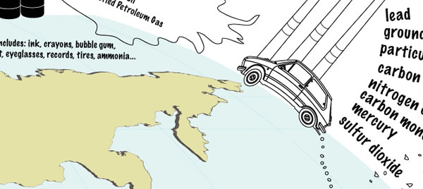
Map: Brooke Singer "The Fossil Fuel Fix"
Essay: Kolya Abramsky "From Animal Traction to Renewable Energy"
We live in a world in which close to half of the worlds population still use basic biomass fuels (unprocessed wood and animal dung) to cook and heat their houses, where women and children often walk for hours to gather these fuels. Even the dream of subsidized air travel and SUVs is beyond the reach of most people. In this context, all too often it is simply the wrong questions that are asked about energy and the current (and future) "energy crisis". The question as to how can the countries with the highest consumption of energy, especially the USA, maintain their "lifestyles" and standards of living becomes the center of attention surely pales in the face of the more confrontational question that strives to address today's enormous global energy inequalities.
Without doubt, people in the US can, and indeed must, play a crucial role in this process, but together with people from around the world, and in a way that simultaneously challenges the inequalities and coerciveness of the current energy regime, but also in a way that challenges that the energy demands of society are set by commercial interests rather than human need.
There is an urgent need for people living in high energy consuming countries (especially the USA) to learn about the existing energy flows and structures in a global context, talking to the people who suffer from it, in Nigeria, in Iraq, in disappearing Islands etc. In addition to this, there is also an urgent need to learn and experiment with other models of energy, including a discussion about public and decommodified forms of producing and consuming energy. And, above all there is the urgency to ensure that a transition to a post-petrol economy (hopefully 100% renewables) will not be trapped into preserving the "American way" at the expense of others.
There is nothing inherently progressive about renewable energies. This is one of the biggest mistakes that advocates of renewable energies can make (and I include myself as one). Renewable energies implemented within existing social relations, while perhaps alleviating some of the worst aspects of climate change, are unlikely to solve other social and ecological problems. In fact, they may even exacerbate them if renewable energy becomes another profit orientated and privately controlled industrial growth sector just like any other.
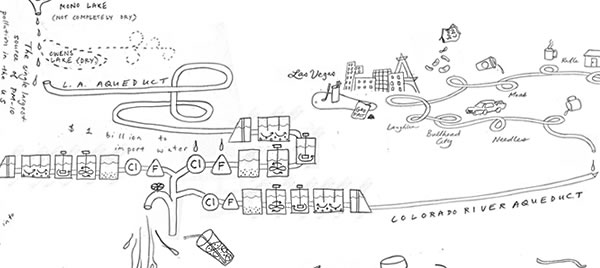
Map: Jane Tsong "The LA Water Cycle"
Essay: Roundtable with Jenny Price, DJ Waldie, Paul Kibel, Ellen Sollod, etc.
Jenny Price: The diagram makes me think about what larger-scale and smaller-scale versions would look like. Larger-scale versions might connect, for example, to Fiji and Switzerland, as sources of bottled water. But smaller-scale versions might show how the water cycle differs for different Angelenos. We don't all drink the same water in LA. Not even close. Take the tap water, for example. Some neighborhoods drink more Owens River water, some more groundwater, some more from the Colorado River. In her new book "Left In the Dust" about LA and the Owens Valley, Karen Piper tells us that the Department of Water and Power mixes Owens River water with polluted groundwater, to the point that the EPA still deems drinkable. The closer you live to the aqueduct, the higher the concentration of Owens River water. So the Valley and the Westside drink water with almost no pollutants, and Central and East and South LA...well, you might want to ask for bottled water at your favorite downtown taqueria....
Jane Tsong: Years ago, plates were installed by all the storm drains throughout the city with a picture of a fish skeleton, and the words "No dumping: this drains to ocean". This is a phenomenal and eye opening image. Without such reminders, one might find it unbelievable that your storm drain runs DIRECTLY to the ocean when you are more than an hour's drive away.
Now what if such plates were required to label all sources of tap water? Your water faucet might say, "from 60% from Owens Valley, 15% from Colorado River, 10% from wells in the San Fernando Valley....", and the one on the toilet might say "drains to the ocean-- wastewater treatment breaks down biodegradable substances only"? What if on each water bottle we purchased, there would be...a real photograph of the actual place the water comes from was required to be shown on the front (instead of a mythical mountain stream), just the way "Nutrition Facts" are now mandated to appear on labels?
Lize Mogel: The no-dumping logo always makes me think of the Hyperion Sewage Treatment Plant (in Los Angeles), which pumps secondary effluent (treated sewage which is considered "cleaned") out into Santa Monica Bay, 5 miles off the shore. Worth noting that the Hyperion plant dumped tons of sewage sludge into the Bay for 30 years until the 1980s, resulting in huge environmental problems. There are always plenty of people swimming at the beach directly in front of the Hyperion plant - not that the treated effluent necessarily rolls back in to that very spot (the LA City website optimistically states that "the water does not return to shore"), but it points to a disconnect between the physical manifestations of the water system and its social meaning.
Shit is always entering the water system, in one form or another. It's a question of how we collectively understand and accept the real meaning of "tap water" or "fresh water" - and how that understanding might change the actions/habits of people, industry, etcetera.
DJ Waldie: Just three little words - "toilet to tap" - in a Daily News headline in April 2000 doomed the Department of Water and Power's goal to do many things with the city's reclaimed water, all designed to stretch local drinking water supplies while retaining, without a draconian conservation regime, the city's illusion of a lush oasis.
"Toilet to tap" in 2000 meant spreading as much as 35,000 acre-feet of highly processed reclaimed water on percolation fields in the Valley. From there, it would migrate, over time, into aquifers 500 or more feet below, mingle with unprocessed water that collects from the hillside watershed. The water would flow through layers of Pleistocene sand, gravel, and silt until, about five years later, the blended water (97% from nature, 3% reclaimed) would appear in city-owned wells to be drawn into the domestic water system where, after a lot of routine testing and chlorination, it would flow from the kitchen taps and hose bibs of Los Angeles households.
It's not enough to know that all water is reused water and that it has passed through a lot of lives in the past 3.5 billion years. Or that the Valley's own watershed, like all the outdoors, is a vast latrine for every thing that doesn't live in a house, and all of nature's effluent, untreated and unregulated, makes some passage into the Valley aquifers.
Not is enough to know that much of the water Los Angeles gets from the Colorado River has previously seen the inside of the septic tanks and sewage systems of upstream cities and arrives here in a condition not much different from the tertiary treated waste water produced by the Tillman Water Reclamation plant [in the San Fernando Valley]...reclaimed water is crucial to maintenance of the region's precarious fresh water balance.
Additional Mapmakers/Writers
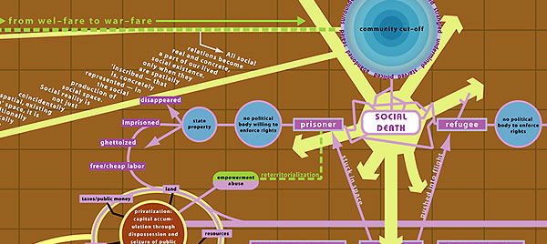
Ashley Hunt / Avery Gordon
on the global prison-industrial complex
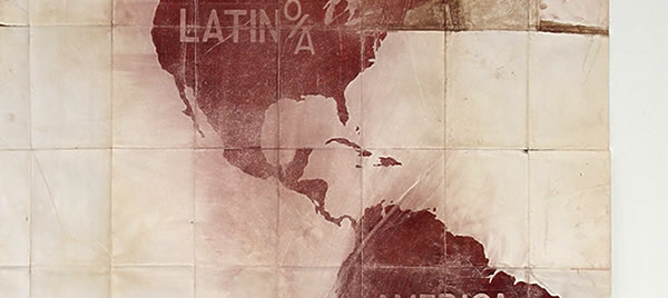
Pedro Lasch / Alejandro DaCosta
on migration in the Americas
Lize Mogel / Sarah Lewison
on geography, gentrification, and globalization
Trevor Paglen & John Emerson / Naeem Mohaiemen
on extraordinary rendition
Unayyan / Jai Sen
on mapping the unintended city in 1980s Calcutta